|
ATTU
(AT-too)
Westernmost
Aleutian Island
Common
clues:
Westernmost part of the U.S.; Westernmost Aleutian; Largest of
the Near Islands; Island of the Aleutians; Alaskan island; North
Pacific island
Crossword
puzzle frequency:
3 times a year
News: Remembering
'forgotten battle' of the Aleutians
Video: Battle
of Attu May-June 1943
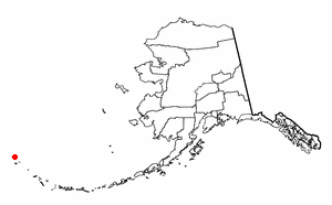
Attu
is the westernmost island in the Near Islands group of the
Aleutian Islands of Alaska, making it the westernmost point of
land in Alaska and the United States. Attu Station is located at
52°51' north latitude, 173°11' east longitude.
It
is nearly 1,700 km (1,100 miles) from the Alaskan mainland and
1200 km (750 miles) northeast of the northernmost of the Kurile
Islands of Japan. Attu is about 32 km (20 miles) by 56 km (35
miles) in size.
The
name Attu is a transliteration of the Aleut name of the island.
It was called Saint Theodore by the explorer Aleksei Chirikov in
1742.
Aleuts
lived on Attu before World War II. But, on June 7, 1942, well
into the war, the Japanese invaded the island. This, as well as
the invasion of nearby Kiska a day earlier, constituted the only
foreign occupation of American soil during the war. The Japanese
relocated the forty-two inhabitants of Attu to a prison camp near
Otaru on the island of Hokkaido; there, sixteen died.

Jarmin
Pass
During
the winter of 1942, the Japanese reinforced and fortified Attu
and Kiska. This was probably not for a greater offensive against
the Aleutian Islands, as some had believed. Instead, the Japanese
were forming a buffer to prevent an American operation in the
Kurile Islands.
On
May 11, 1943, American troops invaded Attu in an attempt to expel
the Japanese forces. This Battle of the Aleutian Islands produced
some of the bloodiest fighting in the Pacific theatre, second
only to Iwo Jima. There were 3929 American casualties; 549 were
killed, 1148 were injured, 1200 had severe cold injuries, 614
succumbed to disease, and 318 died of miscellaneous causes,
largely Japanese booby traps and friendly fire. All in all,
roughly 25% of the American force was killed. On May 29, the last
of the Japanese forces committed suicide rather than be captured;
the result was an American victory. American burial teams counted
2351 Japanese dead, but it was presumed that hundreds more had
been buried over the course of the battle.
After
the war, the survivors of the Otaru prison camp were repatriated
to other Aleutian islands or to the mainland of Alaska, and the
United States government decided to construct a LORAN station on
the southern tip of Attu, at Theodore Point. The equipment to
build the station came out of Holtz Bay and was ferried on barges
and landing craft to Baxter Cove, about one mile east of the
station. Bulldozers were used to cut a road from Baxter Cove to
Theodore Point.
In
1960, the station was moved to Casco Cove, near the former Navy
Base at Massacre Bay. Later it was moved to Massacre Bay.
Weather
The
weather on Attu is typical Aleutian weather: cloudy, rainy, and
foggy. High winds occur occasionally. Five or six days a week are
likely to be rainy, and there are only about eight or ten clear
days a year. The rest of the time, even if rain is not falling,
fog of varying density is the rule rather than the exception.
There are forty to fifty inches of annual rainfall, with the
heaviest rains in autumn and early winter.
This
article is licensed under the GNU
Free Documentation License.
It uses material from the Wikipedia
article "Attu Island".
|