|
URAL
(YER-uhl)
Ural:
River through Russia and Kazakhstan
Ural
Mountains: Europe/Asia divider
Related
crosswordese: URALS
Common
clues:
Russia's ____ Mountains; Russian range; River
of Russia; River through Kazakhstan; Caspian feeder; Russian
flower; Eurasia's ____ Mountains
Crossword
puzzle frequency:
6 times a year
Frequency
in English language:
54594 / 86800
News:
Live
From Russia: Who Knew Boris Yeltsin Was So Funky?
Video:
Bridge
over Ural River
Ural
River
Ural,
known as Yaik before 1775, is a river flowing through Russia and
Kazakhstan. It arises in the southern Ural Mountains and ends at
the Caspian Sea. Its total length is 1,509 mi (2,428 km). It
forms part of the traditional boundary between Europe and Asia.
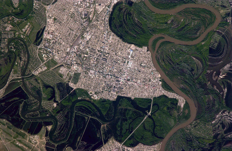
City
of Oral,
Kazakhstan with the Ural River to the right
It
arises on the eastern side of the Urals, about 150 km north of
Magnitogorsk, flows south through Magnitogorsk, and around the
southern end of the Urals, through Orsk where it turns west for
about 300 km, to Orenburg, when the Sakmara River joins. From
Orenburg it continues west, passing into Kazakhstan, then turning
south again at Ural'sk, and meandering through a broad flat plain
until it reaches the Caspian at Atyrau.
Ural
Mountains
The
Ural Mountains are a mountain range that runs approximately from
north to south through western Russia, from the coast of the
Arctic Ocean to the Ural River and northwestern Kazakhstan. Their
eastern side is usually considered the natural boundary between
Europe and Asia. The mountains lie within the Ural geographical
region and significantly overlap with the Ural Federal District
and Ural economic region. They are rich in various deposits,
including metal ores, coal, precious and semi-precious stones,
and since the 18th century have been the major mineral base of
Russia.
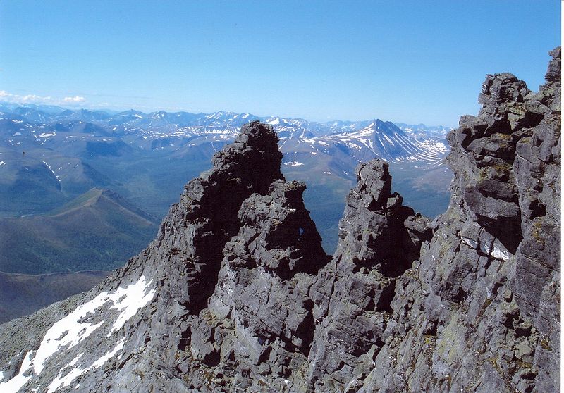
Mountain
formation near Saranpaul, Nether-Polar Urals
The
Ural Mountains extend about 2,500 km (1,550 mi) from the Kara Sea
to the Kazakh steppes along the northern border of Kazakhstan.
Vaygach Island and the island of Novaya Zemlya form a further
continuation of the chain on the north. Geographically this range
marks the northern part of the border between the continents of
Europe and Asia. Its highest peak is Mount Narodnaya (1,895 m or
6,213 ft).
By
topography and other natural features, Ural is divided, from
north to south, into the Polar (or Arctic), Nether-Polar (or
Sub-Arctic), Northern, Central and Southern parts. The Polar Ural
extends for about 385 kilometers (240 miles) from the Mount
Konstantinov Kamen in the north to the Khulga River in the south;
it has an area of about 25,000 km² and a strongly dissected
relief. The maximum height is 1,499 meters (4,915 feet) at the
Payer Mountain and the average height is 1,000–1,100 meters
(3,280–3,605 feet). The mountains of Polar Ural could have
sharp ridges but there are also flattened or rounded tops.
This
article is licensed under the GNU
Free Documentation License.
It uses material from the Wikipedia
article "Ural River" and
“Ural
Mountains”.
URAL
(499) 55
Mo+
>1
99
Caspian feeder
53
Tu+
>1
06
Russia's
___ Mountains
52
Tu
>1 09
Russian
river LENA
NEVA SEIM
37
Tu+
>1
07
River
to the Caspian
36
We-
>1
07
Caspian
Sea feeder
36
We-
>1
06
River
to the Caspian Sea ROID
24
We
>1 09
Orsk's
river
18
We+
>1
09
River
through Kazakhstan
14
Th+
>1
04
Orenburg's
river
11
Tu-
>1
99
Russian
range ALAI
8
Fr-
LAT
08
River
through Orsk
7
>1
97
River
of Russia
6
Mo+
>1
07
Eurasia's
___ Mountains
5
Th+
>1
05
Magnitogorsk's
river
5
Tu+
>1
08
Russian
river to the Caspian
4
Th-
>1
08
Eurasian
river
4
Fr-
>1
04
___-Altaic
languages
07
Asian
range ALAI
3
Fr+
>1
06
Orsk
is on it
3
Th+
LAT
08
River
past Orenburg
3
Th+
>1
04
River
past Orsk
3
Tu+
>1
05
River
through Russia
3
Th
>1 04
Russian
flower
3
Mo
LAT 09
___
Mountains: Europe/Asia border range
2
We
CSy 09
1400-mile
river to the Caspian Sea
|